I haven't posted anything too nerdy lately (although blog posts are nerdy by nature) so I thought I'd mention Picasa Web Albums and Google Maps.
Leah and I share some of our photos online in our Picasa Web Album, and last night I noticed a new Google Maps feature that allows you to map your photography. It's fairly simple - you just drag and drop the photos to the location where they were taken. When you're finished, you can view the photo album via Google Maps or Google Earth - for example, here is our trip to New York City and New Jersey.

And what's cool (loose definition) is that camera manufacturers are starting to include GPS systems in their digital cameras, which means each photo will be marked automatically with longitude and latitude - so the photos will be able to map themselves.
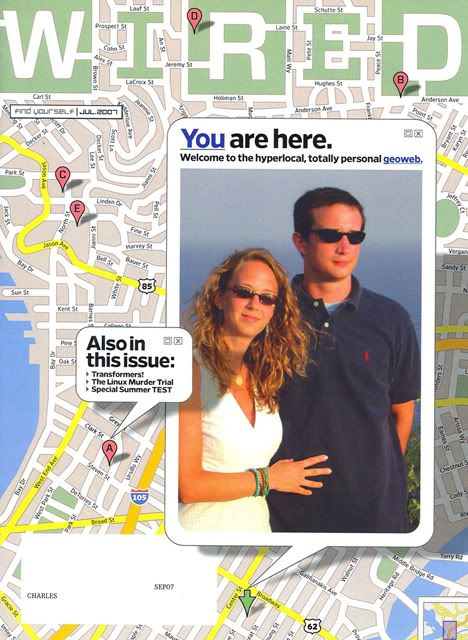
Coincidentally, the July issue of Wired has a nice article about the future of online mapping, and Leah and I are on the cover. Well, not every cover. Just ours. Wired teamed up with Xerox to provide unique covers for 5000 subscribers - whoever does Xerox's marketing should win an award of some kind. Their idea was pretty frickin' groovy.

Leah and I share some of our photos online in our Picasa Web Album, and last night I noticed a new Google Maps feature that allows you to map your photography. It's fairly simple - you just drag and drop the photos to the location where they were taken. When you're finished, you can view the photo album via Google Maps or Google Earth - for example, here is our trip to New York City and New Jersey.

And what's cool (loose definition) is that camera manufacturers are starting to include GPS systems in their digital cameras, which means each photo will be marked automatically with longitude and latitude - so the photos will be able to map themselves.
Coincidentally, the July issue of Wired has a nice article about the future of online mapping, and Leah and I are on the cover. Well, not every cover. Just ours. Wired teamed up with Xerox to provide unique covers for 5000 subscribers - whoever does Xerox's marketing should win an award of some kind. Their idea was pretty frickin' groovy.

